Category Archives: Uncategorized

Preprint by N. Khan et al. on Greenland crevasses detected by deep learning

In July, PhD Candidate Naureen Khan submitted a manuscript entitled “Crevasse locations and meltwater delivery to the bed in Pakitsoq, Greenland: Results from MimiNet, a new deep-learning model for crevasse detection“. The article is now available as a preprint on Earth ArXiv at https://eartharxiv.org/repository/view/7357/ or via DOI at https://doi.org/10.31223/X5QH6C.

Map of an icy area
Crevasse fields (green) and stream/lake (blue) detections by MimiNet overlain on the entire Pakitsoq training region (divided into regions a–f). Purple boxes represent the training dataset of twenty subregions used to train the MimiNet model. Cyan box shows the validation dataset of four subregions used to validate model training at every epoch. Pink stars represent moulin locations over 2009–2019.

Glacier Modeling Lab presentations at AGU 2021

https://res.cloudinary.com/amuze-interactive/image/upload/f_auto,q_auto/v1638741830/agu-fm2021/84-88-ab-27-6b-d5-88-4b-58-2a-a9-93-fc-ba-27-2c/image/helheim_als_scalebymag_trendrm_23_minfrac0.90_pceof1_15-oct-2013-15-may-2021_05-dec-2021_qz9uqy.jpg
Figure from Kristin’s eLightning poster about Helheim Glacier and other glaciers feeding Sermilik Fjord. The leading principal component (blue data on bottom panel) correlates with both the terminus position (p=0.003, red data) and a seasonal cycle with maximum in mid-July (p=0.05, blue dashed line) that is consistent with runoff-control. The terminus position itself correlates to this annual cycle (R=-0.11, p=0.1). Examining p-values and considering some commonality of the forcings, we classify Helheim Glacier as terminus-controlled over 2014-2021.

This agrees with previous classifications of Helheim Glacier as usually terminus-controlled (2009, 2010, 2015, 2016, 2017) [1,2,3] and sometimes runoff-controlled (2013) [1].  It agrees less with a study that found Helheim was runoff-controlled over 2009-2017 [7].
Map of Sermilik Fjord study area
Figure from Kristin’s eLightning poster. Sermilik Fjord, eastern Greenland, contains four major outlet glaciers. Helheim Glacier (westernmost) is the largest. The base map is a mosaic of Sentinel-2 images from summer 2019, by MacGregor et al. (2020). The wintertime terminus positions are from PROMICE.
Group of people in a river canyon

Autumn hike!

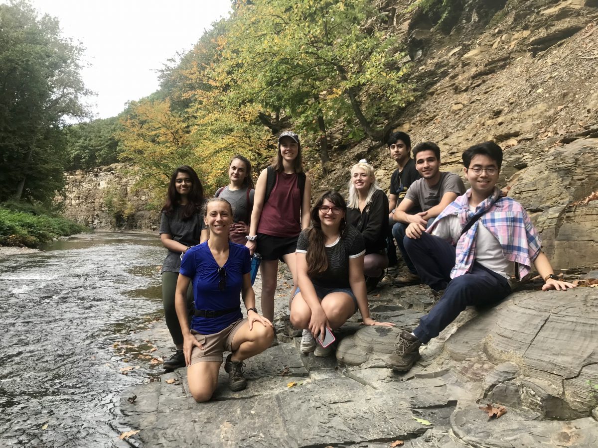
It was a beautiful and unseasonably warm Sunday, so we joined together for a lovely walk in the woods. Eighteen Mile Creek is a short hike (not 18 miles!!) along a canyon rim within a half hour’s drive of the UB campus. We all enjoyed the time outdoors and the break from Sunday homework.

From left to right: Naureen, Kristin, Jess, Courtney, Leah, Hannah, Jorge, Eric, and Donglai. Leah and Donglai are touching shale concretions, which were all over in the creek and on the canyon walls.

We also noticed New Zealand mud snails in the creek — tiny (~5 mm) invasive snails that anchored themselves to the stream bed in fast-flowing areas.

The geology in the canyon walls is Wanakah Shale, which was deposited in the middle Devonian (~385 million years ago). It is full of fossils — trilobites, crinoid stems, and brachiopods — but we did not go looking for these. A local fossil hunting site, Penn Dixie, is the place to go for that!

UB VicTalk: Earth Was An Ice Planet For 20 Million Years

Kristin Poinar gave a VicTalk — a short science lecture — at UB’s Freshman Orientation (“New to UB“) event on August 27, 2021. “New to UB” exposes our new freshmen to academic topics across ~15 different potential majors in the College of Arts and Sciences, even before they begin their first day of classes. It’s a miniature academic conference that invites freshmen to think about the world.

News article “The future of the planet is written in Greenland”

Argemino Barro, a New York-based journalist, interviewed Kristin Poinar for El Ágora, the first Spanish-speaking media entirely devoted to water and climate change. His article is about the future of the Greenland Ice Sheet.

https://www.elagoradiario.com/desarrollo-sostenible/futuro-planeta-groenlandia/
(also see Google translation to English)
La pérdida de hielo de lugares como Groenlandia está aumentando el nivel del mar.
De “El futuro del planeta se escribe en Groenlandia” por Argemino Barro.

GML in person

We had our first and only in-person lab meeting of Spring 2021. It was a brisk spring day on UB’s South Campus, where none of us had ever spent much time. We took a walk around and even spied the Mackay Tower, where a pair of peregrine falcons make their nest. (UB has a webcam — UB Falcon Cam — highly recommended viewing in April through the end of May.)

Lake drainage presentation by Jeremy Stock

Jeremy Stock gave a short talk at the Buffalo Association of Professional Geologists, as part of a Scholarship Event, in spring 2020. The BAPG was prescient and kind enough to share the presentations on the web. Take it away, Jeremy!

Presentation by Jeremy Stock at the Buffalo Association of Professional Geologists, May 2020.

Jeremy’s AGU poster featured some of the same results (but in an earlier form). Check it out here!

Congratulations Jeremy Stock, MS!

Jeremy Stock successfully defended his MS thesis, “Modeled Patterns of Crevassing Induced by Supraglacial Lake Drainage in Western Greenland”, and turned in a very nice dissertation this May. Congratulations, Jeremy!

Abstract:

The Greenland Ice Sheet is expected to contribute substantially to global sea level rise over the next century in response to climate change. As increasing volumes of surface meltwater are delivered to the glacier bed via moulins during supraglacial lake drainage events, it has been hypothesized that new crevasses may form upflow, causing a cascade of lake drainages. This upflow expansion could alter ice sheet dynamics, leading to ice sheet instability and even greater sea level rise contributions. To investigate this hypothesis, we applied an analytical ice-flow model (Gudmundsson, 2008) to calculate surface strain rates and infer the pattern of crevassing induced by a modeled rapidly drained lake. We calibrate the model using data collected during a lake drainage event in the summer of 2011 in the Pakitsoq region of Western Greenland. The patterns and extent of crevassing we see in our model results are highly dependent on the bed topography, basal sliding ratio, dimensions of the slipperiness patch, and the seasonal timing of the drainage event. Our model results show evidence of considerable crevassing occurring within 3-5.5 km upstream of the modeled lake drainage, with crevassing enhanced by a factor of 5-6 within a 3 km radius of the rapidly drained lake. Because lakes in this area are spaced by roughly 2-4 km, our results support the hypothesis for cascading lake drainage. This research improves our understanding of how meltwater may affect ice sheet dynamics, which are a major factor in how much the Greenland Ice Sheet will contribute to sea level rise in the future.

G. H. Gudmundsson. Analytical solutions for the surface response to small amplitude perturbations in boundary data in the shallow-ice-stream approximation. The Cryosphere, 2(2):77–93, 2008. http://doi.org/10.5194/tc-2-77-2008

Modeled Patterns of Crevassing Induced by Supraglacial Lake Drainage in Western Greenland

A few figure excerpts:

Figure 2.12: Flow chart of the data inputs (colored blocks), required parameters (gray circles), and outputs (white circles) produced by the analytical perturbation model (Gudmundsson, 2008). The model outputs are responses to basal perturbations and represent changes to the mean surface elevation (s), mean longitudinal velocity (u), mean transverse velocity (v), and mean vertical velocity (w).
Figure 4.1: Most likely new crevasse locations in response to supraglacial lake drainage. Model results when the study area is centered around lakes 55, 52, 44, 64, 59, and 54. Lake 52 is always shown as a bold circle. Supraglacial lakes are shown as black circles, with the lakes involved in the drainage event outlined twice (Morriss et al., 2013) and GPS stations shown as black triangles (Andrews et al., 2014). The colors indicate where all 3 theoretical strain rate thresholds are exceeded (deep red), 2 thresholds are exceeded (red), 1 threshold is exceeded (orange), and no thresholds are exceeded (tan). The concentric circles are separated by 1 km. We used constant values for mean slip ratio ( ̄C), time (t), and the amplitude of the basal slipperiness patch (Ac) across all tests shown. The diameter of the basal slipperiness patch (Dc) is scaled relative to mean ice thickness ( ̄h) in each location.