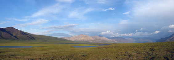
This study examines the current surface conditions of a study area near Toolik Lake, Alaska, and seeks to differentiate the surficial geology and geomorphology, largely influenced by glacial activity, as well as the ecology of the region, in order to characterize the current state of the permafrost table. Using an object-oriented multi-scale segmentation approach, this study will utilize Definiens Professional, a remote sensing application that, among other things, allows for rapid reproduction of GIS-ready information (Definiens 2006), fuzzy analysis of data and integration of multiple data types within the same project. Working in conjunction with ENVI, it will allow for the construction of a model based on spectral properties of the surface materials and hopefully yield more accurate results than a pixel-based classification solely based on a training set.
Data for this thesis project will include Hyperion, EO-1, and Landsat images; as well as, various vector datasets including elevation and land cover.
DOWNLOADS
- Spectral radiometer data for sites near Toolik and Galbraith Lakes, Alaska – Launch
- Poster Presented (low-resolution version) during the 38th annual Arctic Workshop in Boulder, CO
- Poster – Download
Useful Links
- Arctic Long-Term Ecological Research Site – Launch
- Toolik Lake Field Station GIS – Launch
- National Snow and Ice Data Center – Launch
REFERENCE
Definiens AG. (2006). Definiens Professional 5: User Guide v.5.0.6.2. Published by Definiens AG, Munchen, Germany.