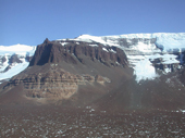
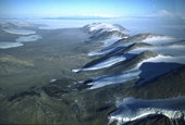
The McMurdo Dry Valleys, covering about 4,800 km², at 76°30’78°30’S, 160-164°E, constitute the largest continuous ice-free ground in Antarctica. It is a hyper-arid, cold polar desert, containing a variety of landscapes, including perennially ice-covered lakes, ephemeral streams, glaciers, and extensive areas of soils and exposed bedrock. Geomorphologic mapping and landscape interpretation provide key information toward understanding the climate evolution of the Dry Valley region, which has important implications for the stability of the east Antarctic ice sheet. (see site map for orientation).
During the 2001-02 Austral summer, NASA/GSFC, NSF Polar Program, and USGS joined forces to collect high-resolution ALS data over several sites in the McMurdo Dry Valleys area of southern Victoria Land, Antarctica, using NASA’s Airborne Topographic Mapper (ATM) laser altimetry system. The prime motivation was to evaluate the potential of ALS topographic mapping in Antarctica and to establish calibration/validation sites for NASA’s ICESat (Ice, Cloud, and land Elevation Satellite) altimeter mission. Data were collected and processed by NASA’s ATM group. The second data processing phase, called as laser point post-processing, was carried out at the Ohio State University.
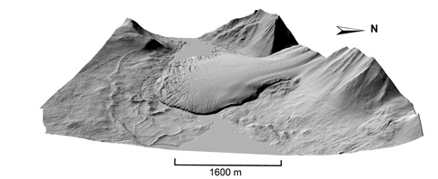
Researchers from the Byrd Polar Research Center and the Digital Photogrammetry Laboratory developed unique methods to analyze the raw laser points, to detect and eliminate outliers, and to interpolate a Digital Elevation Model (DEM) from the irregularly distributed laser points. Different visualization methods are used to represent the surface in a suitable fashion for researchers to analyze the different landscapes. For example, presenting the topography as shaded relief perspective view reveals how well the topographic details have been captured by the airborne laser scanning mission and encoded in the DEM (Canada glacier). This website showcases a few geomorphologic applications that greatly benefit from the high-resolution topographic data. The full data set (that includes the DEMs, label files, and original laser points) is distributed by USGS through the Antarctic Digital Atlas.
Download the DEM of Taylor valley data 1 here
Download the DEM of Taylor valley data 2 here