Long-term mass balance of the Pacific ocean sector of Antarctica based on multisensor fusion. B. Csatho, T. Schenk and C. J. van der Veen, NASA, 2006 – 2009.
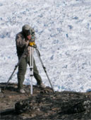
Research Support for R. H. Thomas Science Team member for the Geosciences Laser Altimeter System (GLAS). B. Csatho and D. Bromwich. NASA, 1998 – 2005.
Selected Publications and Presentations
Csatho, B., Y. Ahn, T. Yoon, C.J. van der Veen, S. B. Spikes, G. Hamilton, D. Morse, and S. Vogel, 2005. ICESat measurements reveal complex patterns of thickness changes on Siple Coast ice streams, Antarctica. Geophysical Research Letters, 32, L23S04, doi:1029/2005GL024289.
Schenk, T., B. Csatho, C.J. van der Veen, Y. Ahn and T. Yoon, 2005. Registering imagery to ICESat data for monitoring elevation changes on Byrd Glacier, Antarctica. Geophysical Research Letters, 32, L23S05, doi:10.1029/2005GL024328.
Csatho, B. M., editor, 1999. Proceedings of Joint workshop of ISPRS WG III/5 and III/2 on Mapping surface structure and topography by airborne and spaceborne lasers, International Archives of Photogrammetry and Remote Sensing, 32(3 W14), 214 pages.